

Jul
01
2024
From The Blog
Storm System with Heavy Rains May Bring Flooding
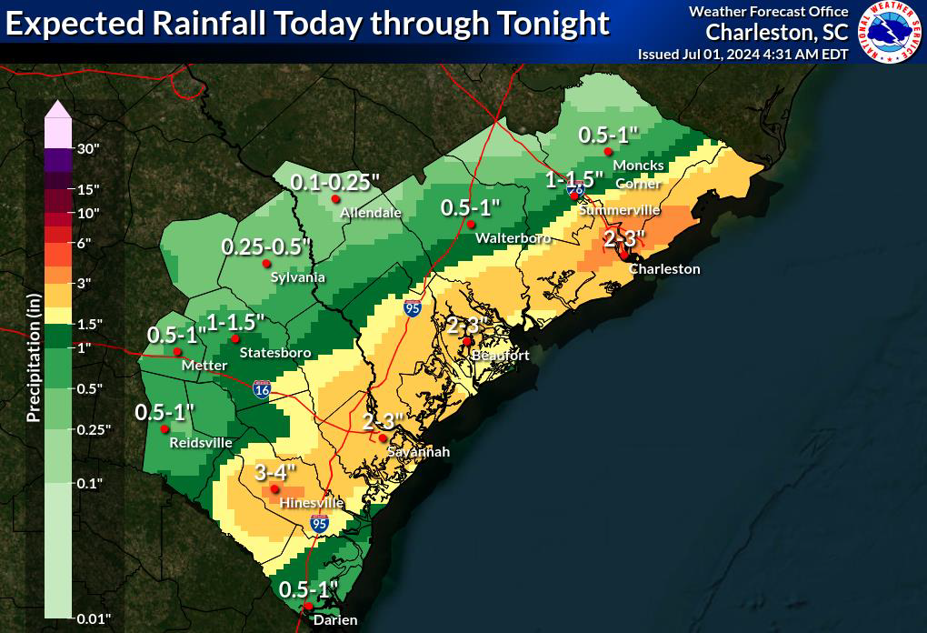
The National Weather Service is predicting multiple rounds of showers and thunderstorms this afternoon. These storms will push through much of Southeast South Carolina and Southeast Georgia bringing a risk for flash flooding, especially near the coast. The area is currently under a flash flood watch, with a flash flood warning expected later today.
Critical Information:
Severe weather is predicted Monday afternoon into evening (12-9 p.m.)
- 2-4 inches of rainfall are predicted, with up to 6 inches possible.
- If Kiawah receives rainfall at the predicted rate (up to 3 inches per hour), standing water is expected on all Kiawah roadways as the drainage system works to move water to the pond system and off the island.
Flooding could occur if heavy rainfall coincides with high tide around 5 p.m.
- Stay home if you can.
- Use caution if you must travel. Expect delays and never travel through standing water.
- View the Town of Kiawah Island’s Flood Guide.
- Kiawah’s gravity-based drainage system will begin moving water off the island as the tide lowers. The next low tide following the storm will be at 11:40 p.m. tonight.
SIGN UP FOR CODE RED ALERTS
Receive phone calls, text messages or emails about severe weather in the area using this service from the Town of Kiawah Island. Sign up now.
CLOSURES
- KICA’s administrative offices are closing at 1:30 p.m. to allow staff to get home before the storm.
- The Sandcastle will be open until 8 p.m., but the Sandcastle Grille and Bar will close at 2 p.m.
WEATHER & LOCAL NEWS
POWER
View Berkeley Electric’s website to view a map of power outages or to report an outage.